3D Laser Scanning FAQs

We are answering some of the frequently asked questions about 3D laser scanning and our process of turning these scans into 3D models, BIM or CAD plans and drawings.
What does BIM stand for?
BIM stands for Building Information Modelling and is an intelligent 3D model-based process that gives architects, engineers and construction (AEC) professionals valuable insights and tools to efficiently plan, design, construct and manage buildings and infrastructure from the ground up.
What is Revit?
Autodesk Revit is a powerful software application used to generate 3D models and BIM. This allows more efficient planning, design, management and construction of projects.
What is the benefit of Revit models over CAD?
Using 3D Revit models allows for precision in design and installation as we are working with precision measurements from laser scanning. Also we are able to create 2D drawings out of 3D Revit models so you can still obtain drawings with more efficiency and accuracy. Learn more about how Architecture use 3D models in our article here.
I don't have Autodesk Revit so how do we view 3D Models?
You can print 2D drawings from Revit so onsite contractors can still mark up blueprints. To view 3D models you can download Navisworks Freedom a free 3D model viewer or Autodek Recap free for 30 days.

What are the advantages of using BIM on a project?
BIM allows all stakeholders, including contractors, to access the project and review information relevant to their involvement. Using the one design saves considerable time, money and materials and minimises rework, errors and waste. Clash co-ordination allow project managers and coordinators to manage and address problems before and during construction to avoid costly mistakes. Learn more about BIM and laser scanning in our article here
What stakeholders should be included in the BIM process?
You can include as many stakeholders as required. At minimum the entire project team including designers, project managers, engineers, consultants, contractors. Best practice is to keep owners, investors and other key stakeholders informed of all developments and construction updates.
What types of drawings can you provide?
We create all types of plans and drawings- Floor plans, Reflected Ceiling plans and views-Elevation, Section. Basically everything from construction and shop drawings to updated as built, BIM and asset management models.
I’m unable to view CAD drawings, i dont have AutoCAD.
You can download Autodesk TrueView a free .dwg viewer.
How do I share large file sizes with you for my project?
We use secure cloud file sharing for transferring large file sizes. We simply send you a secure link to upload and share your files.
What do you need to quote for 3D laser scanning?
When reaching out to a 3D laser scanning company for a quick quote for your project requirement, it helps to provide the following information, if available:
- Site address, access conditions and areas to be included in the laser scan
- What deliverables do you require from the laser scan i.e. point cloud, 3D Revit Model, CAD Plans/Drawings
- If drawings, what types? Floor Plans, Reflected Ceiling Plans, elevation views, cross sections.
- Do you require land surveying plans i.e. Feature and Level, Title Boundary or Re Establishment surveys?
- Any existing plans, mark ups or drawings of the site, building or facility that show the areas to be scanned or surveyed?
If you don’t have all the information, it’s ok. Simply contact the team via phone or email and we can answer any questions you may have.
What is LOD?
Stands for Level of Development more commonly known as Level of Detail. This refers to the amount of detail or information contained within an element in the 3D model. This includes not only graphical objects but also the data associated with the objects. With BIM models, the model will develop over time as the project progresses from a very coarse design to more complex and detailed record of drawings and as builts. To see the differences between LOD watch this video.
Avian uses the appropriate LOD when creating a 3D model of your project based on the specificity required. We offer 5 LOD options from 100 to 500 in line with the internationally accepted standards for LOD.
The below table briefly explains the different LOD Specifications or to learn more about LOD watch this video.
LOD | LOD Specification | Description |
100 | Concept Design | The 3D model represents information on a basic level. Only conceptual model creation is used at this stage. The building will be roughly sized and things like area, height, volume, location and orientation are defined. This allows for basic analysis i.e. whole building energy analysis, conceptual cost based on cost per square foot, and preliminary whole site construction phasing. |
200 | Schematic Design | The model is a general model where elements are modelled with approximate quantities, size, shape, location and orientation. The model will contain the approximate quantity, size, location, and systematic relationships of most objects that will eventually be installed. The data about objects is basic information only although specific object information is available to include at later stages. |
300 | Detailed Design | The Model Element is graphically represented within the Model as a specific system, object or assembly in terms of quantity, size, shape, location, and orientation. Non-graphic information may also be attached to the Model Element. |
400 | Fabrication and Assembly | Model elements are modeled as specific assemblies, with complete fabrication, assembly, and detailing information in addition to precise quantity, size, shape, location and orientation.Non- geometric information to the model elements can also be attached |
500 | As Built | Elements are modeled as constructed assemblies for Maintenance and operations. In addition to actual and accurate in size, shape, location, quantity, and orientation, non-geometric information is attached to modeled elements |
How far does the 3D laser scanner reach?
Why should I use the 3D laser scanner?
In just two words, efficiency and accuracy.
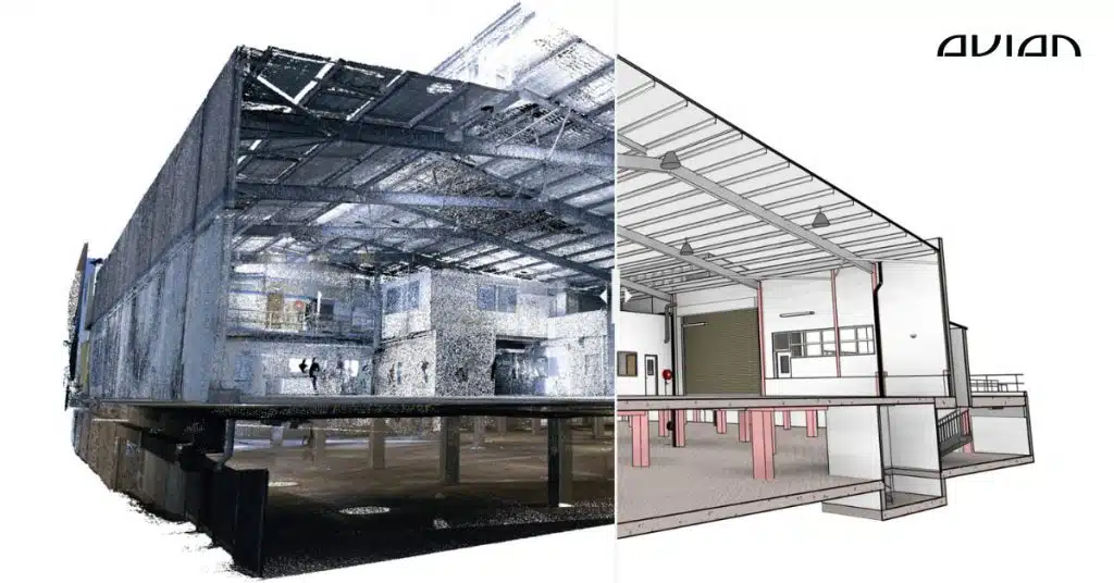
3D laser scanners capture millions of measurements every second using laser light pulses. These measurements create a point cloud which is a 3-dimensional model of the scanned environment. From the point cloud we create 3D models, Plans and Drawings and 3D visualisations (virtual site tours, walk-throughs and Architectural renders). To do this manually with a disto, well its not even worth considering…